With the cleanup completed, the U.S. Environmental Protection Agency removed the Portsmouth Naval Shipyard from the National Superfund List in the fall of 2023.
Superfund cleanup at the Portsmouth Naval Shipyard began in 1995 and continued until the completion of the project in 2023. SAPL worked with state and federal agencies and helped oversee the process as a community consultant through the Environmental Protection Agency’s TAG Program. While the Superfund cleanup is complete, the Navy will continue monitoring toxic sites and has put deed restrictions at several sites, in the event that the facility becomes available for other use in coming decades.
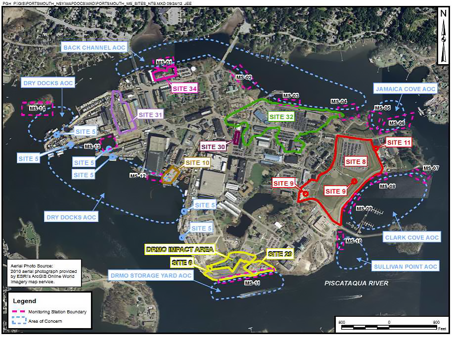
BRIEF OVERVIEW OF SHIPYARD TOXICS
From 1945 to 1975, untreated acid and alkaline waste; waste battery acid and lead sludge; wastewater and spent electroplating baths; as well as other toxins were discharged into the Piscataqua River via industrial waste outfalls.
Additionally, from 1945 until about 1978, 25 acres of tidal flats were filled with toxic landfill, including chromium-, lead-, and cadmium-plating sludge; asbestos insulation; volatile organic compounds (VOCs); waste paint and solvents; mercury-contaminated materials; sandblasting grit containing various metal wastes; and dredged sediments from the Piscataqua River.
Contaminants at the Portsmouth Naval Shipyard (Seavey Island) include mercury, benzene, thallium, polychlorinated biphenyls (PCBs), polycyclic aromatic hydrocarbon (PAHs), dioxin, arsenic, lead, and others. They are found in varying locations including groundwater, soil, and sediment. Each of these contaminants were addressed in the cleanup process.
SAPL’s work with the Shipyard was funded in large part by a Technical Assistance Grant from the EPA. Technical Assistance Grants (TAG) help communities participate in and oversee Superfund cleanup to ensure that their community is protected. The funding enabled us to contract our own independent technical advisor to interpret and explain site conditions, technical reports, EPA’s cleanup proposals, and decisions.
You can learn more about contamination at the Portsmouth Naval Shipyard on the EPA website:
RISING SEA LEVEL: A CONTINUED CONCERN FOR THE SHIPYARD
With sea level rising at an accelerating rate, coastal military installations are increasingly exposed to storm surge and tidal flooding. The Union of Concerned Scientists (UCS) conducted analyses of this changing exposure for 18 installations along the East and Gulf coasts.
Analysis for Portsmouth Naval Shipyard found that in the second half of this century, in the absence of preventive measures, the installation can expect frequent and extensive tidal flooding, loss of currently utilized land, and substantial increases in the extent and severity of storm-driven flooding to which it is exposed.
Read the UCS factsheet on Coastal Flooding at the Shipyard »
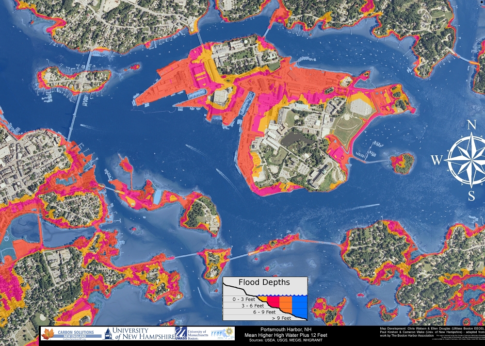
While the Portsmouth Naval Shipyard sees relatively little tidal flooding today, low-lying areas of coastal New Hampshire and southern Maine are already experiencing an increase in tidal flooding.
If the rate of sea level rise this century continues to increase as projected, extreme high tides could eventually bisect the Shipyard and erode previously filled areas of Seavey Island.
Image: Map showing 100-year flood inundation levels, created by NH GRANIT, New Hampshire’s statewide geographic information system (GIS) as part of their carbon solutions program. NH GRANIT is a project of UNH’s Earth Systems Research Center.